
We used spatial indexing several times but we have still not discussed what is it. If you know about programming, you already have an idea about indexing. If not, it is like creating shortcuts to referred items. For example, we can index a column by creating an associative array (object if you like) and storing distinct values as keys and features having them as values. This way, we reduce the time complexity of a single selection from O(n) to O(1).
Spatial indexing is based on the same principle--we index geometries to reduce the time complexity of spatial algorithms. However, indexing geometries, even represented in a binary format, is unfeasible in almost every possible way. Hence, we usually use bounding boxes to index geometries. These structures are collectively called Bounding Volume Hierarchies (BVH), among which the R-tree is the most popular one. Both QGIS and PostGIS use R-Trees to index geometries. The R-tree stores the axis-oriented minimum bounding rectangles of geometries. That is, every rectangle is the smallest standing rectangle encompassing the whole geometry.
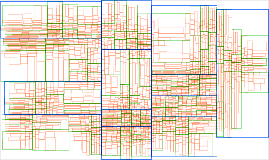
As the name suggests, these bounding rectangles are put into hierarchy. Bigger bounding rectangles of these rectangles get calculated based on the implementation. Simple implementations do less partitioning, balancing, and optimizations in the hierarchy, resulting in a performance hit when there are a lot of changes in the tree. However, it does not matter how carefully the R-tree is constructed; searching it remains the same: we start by querying the biggest rectangles, iterating through smaller rectangles in them, finally arriving to the bounding rectangles of our features of interest, effectively ending up with only relevant features in sublinear time (in average case). RBush, Vladimir Agafonkin's R-Tree implementation has a great demo showing how these structures work (for 50,000 features), as shown in the following image:
If we look at the PostGIS tables from QGIS, we can see some info about the spatial index QGIS created automatically; however, there is no detailed information. However, if we inspect one of our spatial tables in pgAdmin, we can see the exact SQL query creating the spatial index, which is as follows:
    CREATE INDEX sidx_adm1_geom
    ON adm1
    USING gist
    (geom);
So, a named index (sidx_adm1_geom) was created for our layer (adm1) based on the column containing geometries (geom). There is only one thing that is unclear--what is gist? Generalized Search Tree (GiST) is an indexing scheme which uses B-tree and, more importantly, gives a nice template to build other indexing mechanisms on. The creators of PostGIS used its extensibility to build their own R-tree implementation.