Let's see how the projection we used since the beginning of the book works. It is the EPSG:4326, or Plate Carrée (flat square), which is a coordinate system with an equirectangular projection using the WGS84 (World Geodesic System 1984) ellipsoid.
We need a mathematical model to begin with, as the real shape of Earth is uneven, and therefore, very hard to represent mathematically. The most simple shape we can model Earth with is a sphere. As there is a great difference between the real size of Earth and the optimal sphere that it can be represented with, we can use a little more complex shape to increase overall accuracy--an ellipsoid. As Earth is a little flattened on the poles, an ellipsoid (technically an oblate spheroid) offers the best fit from simple shapes. It is used by most of the projections. An ellipsoid has two very important parameters--a size and flattening, which minimizes the difference from the shape of Earth for a use case. The WGS84 ellipsoid strives for the best overall accuracy.
The second thing we need is a datum. The datum is the referenced ellipsoid. By referencing an ellipsoid, we bind its center to somewhere in or on Earth. In the Plate Carrée, we have a WGS84 datum, which binds the center of the WGS84 ellipsoid to Earth's center of mass. This is a somewhat special case, which is very easy to understand, as Earth's center of mass does not change much, only our measurements get more accurate.
The last thing we need is a projection. A projection is a method to transform coordinates on our model to a flat surface. Therefore, we need a shape which can be flattened out seamlessly, and a function to map coordinates. Plate Carrée is a perspective projection. Perspective projections work like an object put into the path of light. It casts a shadow on the surface behind it, and that shadow is the projected image of the object (in our case, the reference ellipsoid). Let's imagine our ellipsoid as a totally transparent crystal spheroid with borders of the countries painted on it as narrow black lines. We can imagine that the properties of the shadow it casts depend on two factors--the place where we put our light source (perspective point), and the shape of the surface behind it (projection surface).
Based on the perspective point, we have a lot of options, although these are three distinct, specific cases which are used often in cartography:
- Orthographic: The perspective point is in infinity, therefore, the light rays are parallel
- Gnomonic: The perspective point is in the middle of the ellipsoid; it is mainly used for polar maps
- Stereographic: The perspective point is at the far end of the ellipsoid
Based on the projection surface, we also distinguish between these three distinct cases:
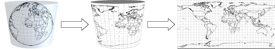
- Cylindrical: We wrap our ellipsoid in a cylinder, and project the whole ellipsoid by rotating the light source. We flatten out our cylinder by cutting it, and get a rectangular map.
- Planar: We project our ellipsoid on a plane, and get a circle-shaped map as a result.
- Conic: We place a cone on the opposite side of our ellipsoid as our perspective point. We flatten out our cone by cutting it, and get a map with a shape of a half circle.
The Plate Carrée is one of the simplest perspective projections possible - it is an orthographic cylindrical projection. It is normal (the top and bottom sides of the cylinder are parallel to the Equator), thus it has a starting longitude (λ0) of 0°, and a starting latitude (φ0) of 0°. Hence, it is a simple linear mapping of geographic coordinates to the projected coordinates (x = λ, y = φ):