
The steps you need to follow to complete this recipe are as follows:
- As an initial test, you will export the first six months of the tmax for 2012 (the first six bands in the tmax_2012_multi PostGIS raster table) using the gdal_translate command:
      $ gdal_translate -b 1 -b 2 -b 3 -b 4 -b 5 -b 6
      PG:"host=localhost port=5432 dbname='postgis_cookbook'
      user='me' password='mypassword' schema='chp01'
      table='tmax_2012_multi' mode='2'" tmax_2012_multi_123456.tif
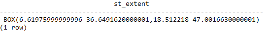
- As the second test, you will export all of the bands, but only for the geographic area containing Italy. Use the ST_Extent command to get the geographic extent of that zone:
      postgis_cookbook=# SELECT ST_Extent(the_geom)
      FROM chp01.countries WHERE name = 'Italy';
The output of the preceding command is as follows:
- Now use the gdal_translate command with the -projwin option to obtain the desired purpose:
      $ gdal_translate -projwin 6.619 47.095 18.515 36.649
      PG:"host=localhost port=5432 dbname='postgis_cookbook'
      user='me' password='mypassword' schema='chp01'
      table='tmax_2012_multi' mode='2'" tmax_2012_multi.tif
- There is another GDAL command, gdalwarp, that is still a convert utility with reprojection and advanced warping functionalities. You can use it, for example, to export a PostGIS raster table, reprojecting it to a different spatial reference system. This will convert the PostGIS raster table to GeoTiff and reproject it from EPSG:4326 to EPSG:3857:
      gdalwarp -t_srs EPSG:3857 PG:"host=localhost port=5432
      dbname='postgis_cookbook' user='me' password='mypassword'
      schema='chp01' table='tmax_2012_multi' mode='2'"
      tmax_2012_multi_3857.tif