Table of Contents for
OpenLayers 3.x Cookbook - Second Edition
 OpenLayers 3.x Cookbook - Second Edition
Published by
Packt Publishing, 2016
OpenLayers 3.x Cookbook - Second Edition
Published by
Packt Publishing, 2016
- Cover
- Table of Contents
- OpenLayers 3.x Cookbook Second Edition
- OpenLayers 3.x Cookbook Second Edition
- Credits
- About the Authors
- About the Reviewer
- www.PacktPub.com
- Preface
- What you need for this book
- Who this book is for
- Sections
- Conventions
- Reader feedback
- Customer support
- 1. Web Mapping Basics
- Creating a simple fullscreen map
- Playing with the map's options
- Managing the map's stack layers
- Managing the map's controls
- Moving around the map view
- Restricting the map's extent
- 2. Adding Raster Layers
- Using Bing imagery
- Using OpenStreetMap imagery
- Adding WMS layers
- Changing the zoom effect
- Changing layer opacity
- Buffering the layer data to improve map navigation
- Creating an image layer
- Setting the tile size in WMS layers
- 3. Working with Vector Layers
- Adding a GML layer
- Adding a KML layer
- Creating features programmatically
- Exporting features as GeoJSON
- Reading and creating features from a WKT
- Using point features as markers
- Removing or cloning features using overlays
- Zooming to the extent of a layer
- Adding text labels to geometry points
- Adding features from a WFS server
- Using the cluster strategy
- Reading features directly using AJAX
- Creating a heat map
- 4. Working with Events
- Creating a side-by-side map comparator
- Implementing a work-in-progress indicator for map layers
- Listening for the vector layer features' events
- Listening for mouse or touch events
- Using the keyboard to pan or zoom
- 5. Adding Controls
- Adding and removing controls
- Working with geolocation
- Placing controls outside the map
- Drawing features across multiple vector layers
- Modifying features
- Measuring distances and areas
- Getting feature information from a data source
- Getting information from a WMS server
- 6. Styling Features
- Styling layers
- Styling features based on geometry type
- Styling based on feature attributes
- Styling interaction render intents
- Styling clustered features
- 7. Beyond the Basics
- Working with projections
- Creating a custom control
- Selecting features by dragging out a selection area
- Transitioning between weather forecast imagery
- Using the custom OpenLayers library build
- Drawing in freehand mode
- Modifying layer appearance
- Adding features to the vector layer by dragging and dropping them
- Making use of map permalinks
- Index
The goal of this recipe is to show us how we can work directly with AJAX requests and load content from different data sources on the same vector layer.
OpenLayers allows us to read data from different origins and sources. We've seen that we can connect to a variety of services (such as WMS and WFS) and/or customize the request according to our needs (such as providing a URL directly pointing to a GML file).
We've seen that providing a URL and format type to the vector source is convenient and works for many cases. OpenLayers makes the AJAX request for us and automatically formats the response. However, there are times when we need even more control over the AJAX request and response, and this is where the loader function comes into play.
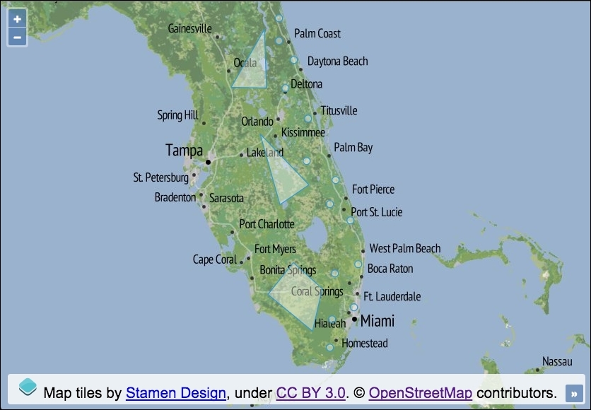
We have chosen to use jQuery to perform the AJAX requests. The requests will pull in two separate geometry files of different formats and add them both to the same vector layer. The source code for this recipe can be found in ch03/ch03-reading-features-from-ajax/. Here's the resulting geometry that we'll collate and render on the map:
Create your custom AJAX loader using the following instructions:
- Create an HTML file and add the OpenLayers dependencies and the jQuery library. Add a
divelement to hold the map. - Next, initialize the
map, add a raster layer, and center the viewport:var map = new ol.Map({ view: new ol.View({ zoom: 7, center: [-9039137, 3169996] }), target: 'js-map', layers: [ new ol.layer.Tile({ source: new ol.source.Stamen({layer: 'terrain'}) }) ] }); - Now, create a vector layer with a source that's responsible for making the multiple AJAX requests to fetch the two geometry files. Parse and then add the returned data to the vector source features list:
var vectorLayer = new ol.layer.Vector({ source: new ol.source.Vector({ loader: function() { $.ajax({ type: 'GET', url: 'points.wkt', context: this }).done(function(data) { var format = new ol.format.WKT({splitCollection: true}); this.addFeatures(format.readFeatures(data)); }); $.ajax({ type: 'GET', url: 'polygons.json', context: this }).done(function(data) { var format = new ol.format.GeoJSON(); this.addFeatures(format.readFeatures(data)); }); } }) }); - Add the vector layer to the
map:map.addLayer(vectorLayer);
Let's get straight to it and break down the important parts of this recipe:
source: new ol.source.Vector({
  loader: function() {
We use the loader property of the vector source to provide a custom function of type ol.FeatureLoader. Similar to the url property (which takes a function type of ol.FeatureUrlFunction), the loader function is also passed extent, resolution, and projection, respectively. We've omitted these as we don't make any use of them for our requests.
$.ajax({
  type: 'GET',
  url: 'points.wkt',
  context: this
With the help of jQuery, we set up an HTTP GET request, pointing towards a local geometry file, packed with points in the WKT format.
Within the loader function, the this keyword in JavaScript points to the vector source. We intend to use this reference when we add the returned features to the source from within the AJAX promise (done). jQuery offers a useful property called context that enables us to specify what the value of this references in the callbacks or promises. This saves us writing temporary variables or referencing the vector source in another way.
}).done(function(data) {
  var format = new ol.format.WKT({splitCollection: true});
  this.addFeatures(format.readFeatures(data));
});
Once the AJAX request has responded with success, our done promise is fired. The data parameter contains the content of the WKT file.
When the WKT format object is created, we pass a configuration object with the splitCollection property set to true. By default, OpenLayers will wrap the WKT geometries into a geometry collection, but we'd prefer each point to be classified as an individual feature in the feature collection. This is really just minor semantics for our example.
The features are processed (format.readFeatures) and added to the vector source (this.addFeatures), this is the equivalent of vectorLayer.getSource() here.
$.ajax({
  type: 'GET',
    url: 'polygons.json',
    context: this
  }).done(function(data) {
    var format = new ol.format.GeoJSON();
    this.addFeatures(format.readFeatures(data));
  });
This request is the same as the previous request, although this time around, we fetch a file containing data in the GeoJSON format. The features are added to the same vector layer.
When using the loader function, we are responsible for loading and adding the features to the layer ourselves.