Table of Contents for
OpenLayers 3 : Beginner's Guide
 OpenLayers 3 : Beginner's Guide
Published by
Packt Publishing, 2015
OpenLayers 3 : Beginner's Guide
Published by
Packt Publishing, 2015
- Cover
- Table of Contents
- OpenLayers 3 Beginner's Guide
- OpenLayers 3 Beginner's Guide
- Credits
- About the Authors
- About the Reviewers
- www.PacktPub.com
- Preface
- What you need for this book
- Who this book is for
- Sections
- Time for action – heading
- Conventions
- Reader feedback
- Customer support
- 1. Getting Started with OpenLayers
- Advantages of using OpenLayers
- What, technically, is OpenLayers?
- Anatomy of a web mapping application
- Connecting to Google, Bing Maps, and other mapping APIs
- Time for action – downloading OpenLayers
- Time for action – creating your first map
- Where to go for help
- OpenLayers issues
- OpenLayers source code repository
- Getting live news from RSS and social networks
- Summary
- 2. Key Concepts in OpenLayers
- Time for action – creating a map
- Time for action – using the JavaScript console
- Time for action – overlaying information
- OpenLayers' super classes
- Key-Value Observing with the Object class
- Time for action – using bindTo
- Working with collections
- Summary
- 3. Charting the Map Class
- Time for action – creating a map
- Map renderers
- Time for action – rendering a masterpiece
- Map properties
- Time for action – target practice
- Map methods
- Time for action – creating animated maps
- Events
- Views
- Time for action – linking two views
- Summary
- 4. Interacting with Raster Data Source
- Layers in OpenLayers 3
- Common operations on layers
- Time for action – changing layer properties
- Tiled versus untiled layers
- Types of raster sources
- Tiled images' layers and their sources
- Time for action – creating a Stamen layer
- Time for action – creating a Bing Maps layer
- Time for action – creating tiles and adding Zoomify layer
- Image layers and their sources
- Using Spherical Mercator raster data with other layers
- Time For action – playing with various sources and layers together
- Time For action – applying Zoomify sample knowledge to a single raw image
- Summary
- 5. Using Vector Layers
- Time for action – creating a vector layer
- How the vector layer works
- The vector layer class
- Vector sources
- Time for action – using the cluster source
- Time for action – creating a loader function
- Time for action – working with the TileVector source
- Time for action – a drag and drop viewer for vector files
- Features and geometries
- Time for action – geometries in action
- Time for action – interacting with features
- Summary
- 6. Styling Vector Layers
- Time for action – basic styling
- The style class
- Time for action – using the icon style
- Have a go hero – using the circle style
- Multiple styles
- Time for action – using multiple styles
- Style functions
- Time for action – using properties to style features
- Interactive styles
- Time for action – creating interactive styles
- Summary
- 7. Wrapping Our Heads Around Projections
- Time for action – using different projection codes
- Time for action – determining coordinates
- OpenLayers projection class
- Transforming coordinates
- Time for action – coordinate transforms
- Time for action – setting up Proj4js.org
- Time for action – reprojecting extent
- Time for action – using custom projection with WMS sources
- Time for action – reprojecting geometries in vector layers
- Summary
- 8. Interacting with Your Map
- Time for action – converting your local or national authorities data into web mapping formats
- Time for action – testing the use cases for ol.interaction.Select
- Time for action – more options with ol.interaction.Select
- Introducing methods to get information from your map
- Time for action – understanding the forEachFeatureAtPixel method
- Time for action – understanding the getGetFeatureInfoUrl method
- Adding a pop-up on your map
- Time for action – introducing ol.Overlay with a static example
- Time for action – using ol.Overlay dynamically with layers information
- Time for action – using ol.interaction.Draw to share new information on the Web
- Time for action – using ol.interaction.Modify to update drawing
- Understanding interactions and their architecture
- Time for action – configuring default interactions
- Discovering the other interactions
- Time for action – using ol.interaction.DragRotateAndZoom
- Time for action – making rectangle export to GeoJSON with ol.interaction.DragBox
- Summary
- 9. Taking Control of Controls
- Adding controls to your map
- Time for action – starting with the default controls
- Controls overview
- Time for action – changing the default attribution styles
- Time for action – finding your mouse position
- Time for action – configuring ZoomToExtent and manipulate controls
- Creating a custom control
- Time for action – extending ol.control.Control to make your own control
- Summary
- 10. OpenLayers Goes Mobile
- Using a web server
- Time for action – go mobile!
- The Geolocation class
- Time for action – location, location, location
- The DeviceOrientation class
- Time for action – a sense of direction
- Debugging mobile web applications
- Debugging on iOS
- Debugging on Android
- Going offline
- Time for action – MANIFEST destiny
- Going native with web applications
- Time for action – track me
- Summary
- 11. Creating Web Map Apps
- Using geospatial data from Flickr
- Time for action – getting Flickr data
- A simple application
- Time for Action – adding data to your map
- Styling the features
- Time for action – creating a style function
- Creating a thumbnail style
- Time for action – switching to JSON data
- Time for action – creating a thumbnail style
- Turning our example into an application
- Time for action – adding the select interaction
- Time for action – handling selection events
- Time for action – displaying photo information
- Using real time data
- Time for action – getting dynamic data
- Wrapping up the application
- Time for action – adding dynamic tags to your map
- Deploying an application
- Creating custom builds
- Creating a combined build
- Time for action – creating a combined build
- Creating a separate build
- Time for action – creating a separate build
- Summary
- A. Object-oriented Programming – Introduction and Concepts
- Going further
- B. More details on Closure Tools and Code Optimization Techniques
- Introducing Closure Library, yet another JavaScript library
- Time for action – first steps with Closure Library
- Making custom build for optimizing performance
- Time for action – playing with Closure Compiler
- Applying your knowledge to the OpenLayers case
- Time for action - running official examples with the internal OpenLayers toolkit
- Time for action - building your custom OpenLayers library
- Syntax and styles
- Time for action – using Closure Linter to fix JavaScript
- Summary
- C. Squashing Bugs with Web Debuggers
- Time for action – opening Chrome Developer Tools
- Explaining Chrome Developer debugging controls
- Time for action – using DOM manipulation with OpenStreetMap map images
- Time for action – using breakpoints to explore your code
- Time for action – playing with zoom button and map copyrights
- Using the Console panel
- Time for action – executing code in the Console
- Time for action – creating object literals
- Time for action – interacting with a map
- Improving Chrome and Developer Tools with extensions
- Debugging in other browsers
- Summary
- D. Pop Quiz Answers
- Chapter 5, Using Vector Layers
- Chapter 7, Wrapping Our Heads Around Projections
- Chapter 8, Interacting with Your Map
- Chapter 9, Taking Control of Controls
- Chapter 10, OpenLayers Goes Mobile
- Appendix B, More details on Closure Tools and Code Optimization Techniques
- Appendix C, Squashing Bugs with Web Debuggers
- Index
We will inspect reusing the workflow for developing the OpenLayers core library to run the official examples. For this purpose, start with the following step:
- Download the project code in your command line:
git clone https://github.com/openlayers/ol3.git
cd ol3
git checkout v3.0.0
- Install Node and Python additional libraries with:
npm install
sudo pip install -r requirements.txt
- Run from the command line, on Windows,
build.cmd checkdepsor./build.py checkdepson Linux / Mac OSX. It will return if dependencies are solved to proceed to the next step. - To retrieve Closure Compiler and use the automatic configuration from the OpenLayers project, launch on Microsoft Windows:
build.cmd
build.cmd host-examples
build.cmd serve
- On Linux / Mac OSX:
./build.py
./build.py host-examples
./build.py serve
Note
You may need an offline API, if for example, you're working in public transportation or without a network connection. To generate it, execute the
./build.py apidocorbuild.cmd apidoc. Then, open it withhttp://localhost:3000/build/hosted/HEAD/apidoc/. You can also get it directly from thev3.0.0.zipfile, downloaded from Chapter 1, Getting Started with OpenLayers. - Now, open your browser at
http://localhost:3000/examples/and open Google Chrome Developers Tools. You will see the examples like the one you get on the official website that follows: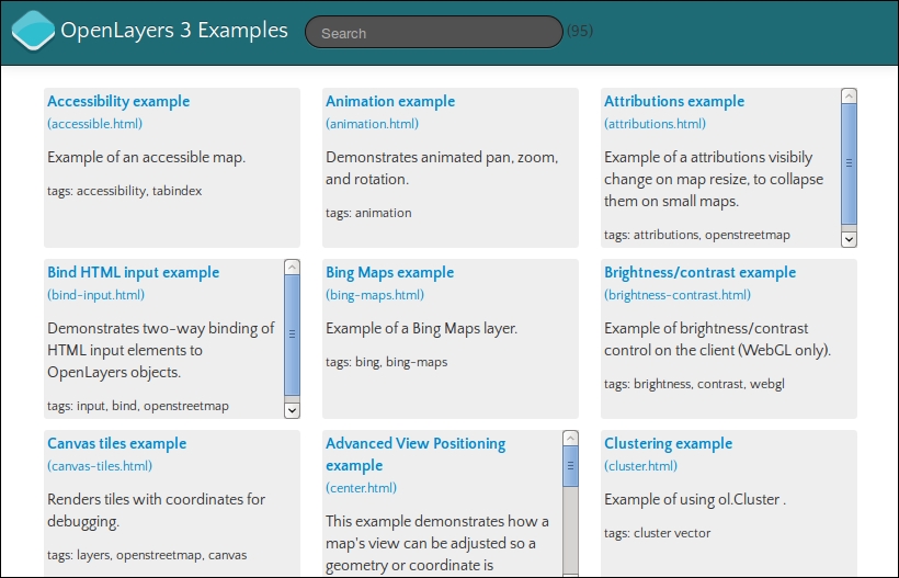
- Explore the examples and watch for the Elements, Network, and Sources panel, in particular the JavaScript calls.
- Then, navigate to
http://localhost:3000/build/hosted/HEAD/examples/attributions.html. - Try to add the URL of the examples
?mode=whitespaceor?mode=simple, or?mode=raw.
We serve files on a small web server. In the first case, the loader.js file retrieves the dependencies and adds for each required files the script tag with the src attribute. In the second case, we chose to open the hosted files, the ones you get when you browse the official website, http://openlayers.org.
In the second case, depending on the provided values for the mode parameter, we will load different files for the OpenLayers 3 library:
- Raw: This loads each input via its own
<script>tag. This does not run the Compiler, so no checks are performed. - Whitespace: This loads all of the JavaScript code concatenated together with all white space and comments removed.
- Simple: This loads the JavaScript as compiled with
SIMPLE_OPTIMIZATIONSenabled. Without an option in the URL, this loads the JavaScript as compiled withADVANCED_OPTIMIZATIONSenabled.
Hey! These options look familiar, where did we see them?
Remember that we had mentioned to you that OpenLayers tools are using Closure Compiler. Let's see how OpenLayers takes benefits from it.
When you changed examples with the raw mode, you may have noticed (in particular by filtering the script in the Network panel) that the loaded files number greatly differs from the URL without it. What can make this difference? Let's see some practical uses to understand.
We waited until now to review the removal of the unused code feature related to Google Closure Compiler.
As we already said, when you switch between examples, you load different files. How does it work?
Open your browser Network panel. Open the URL for one of the official examples and add ?mode=raw.
Then, in the console, type console.log(paths.length);.
Just compare the length between the examples. If your example in the URL is animation.html, inspect also the animation-require.js files, you will see that there are some lines beginning with goog.require('...'). The loader gets the name from the file via loader?id=examplename, and with the goog.require indications from examplename-require.js, Closure Compiler generates the list of files to load for the example.
When Compiler does not find the required goog.require statements, it excludes the files and the resulting build file is smaller. On mobile applications, it is invaluable. Just be careful to not break your application, for example, if you forget to add a statement.
When you run ./build.py or build.cmd, you have something such as 2014-12-10 18:41:23,358 build/ol.js: node tasks/build.js config/ol.json build/ol.js. We will reuse the beginning command to compile the ol.js file again and play with the Closure Compiler builder included in the OpenLayers 3 toolkit. The ol.json file is used to provide parameters to Closure Compiler to make the build and ol.js is the output result.
To build, you have two choices:
- Build the code to make it work with a separate
.jslightened build - Build the code by including the OpenLayers library code, together with the script file
At the moment, you have a shared JSON file for all examples in config/examples-all.json. We will reuse it.